Beach Road | |
|---|---|
 | |
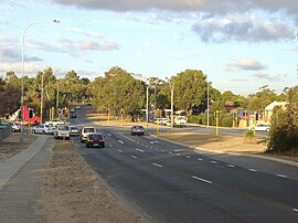
| View east towards intersection with Wanneroo Road | |
 | |
| General information | |
| Type | Road |
| Length | 14 km (8.7 mi) |
| Opened | 1900 |
| Major junctions | |
| West end | |
| |
| East end | Marshall Road, Malaga |
| Location(s) | |
| Major suburbs | Duncraig, Carine, Warwick, Hamersley, Balga, Mirrabooka, Malaga |
| ---- | |


Beach Road is a major east–west road in the northern suburbs of Perth, Western Australia, connecting Perth's inner northern beachside suburbs and inland state housing areas with shopping and public transport facilities at Warwick and the Malaga industrial area. It was mostly built between 1967 and 1974,[1] and is a dual carriageway for most of its length, except for a small western part between Marmion Avenue and the coast, which is a minor residential distributor road and is discontinuous at Marmion Avenue.[2] Beach Road also serves as a local government boundary. From Alexander Drive to Wanneroo Road, Beach Road is the boundary with the City of Wanneroo on the northern side and the City of Stirling on the southern side. From Wanneroo Road to the coast Beach Road is the boundary with the City of Joondalup (part of City of Wanneroo until 1998) on the northern side and the City of Stirling on the southern side.
Beach Road is unusual in two respects: despite its size and traffic levels, and the fact it crosses Mitchell Freeway, it does not have entry or exit to the freeway – one of only two major east-west roads not to do so (along with Scarborough Beach Road) – and secondly, it was not assigned a route number when Main Roads Department introduced the State Route system in 1986.
- ^ Metropolitan Street Directory (9th-16th editions; 1968-1975) Department of Lands and Surveys, Perth. Accessed at Battye Library, Perth.
- ^ Department of Land Information. StreetSmart Perth Street Directory (54th ed.). West Australian Newspapers Ltd. pp. Map 280-283. ISBN 978-0-909439-67-5.