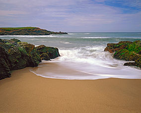
| Bean Hollow State Beach | |
|---|---|
 | |
| Location | San Mateo County, California, United States |
| Nearest city | Pescadero, California |
| Coordinates | 37°13′33″N 122°24′32″W / 37.22583°N 122.40889°W |
| Area | 44 acres (18 ha) |
| Established | 1958 |
| Governing body | California Department of Parks and Recreation |
Bean Hollow State Beach is a beach in the state park system of California, United States. It is located in San Mateo County near Pescadero. The beach offers fishing, picnicking and beachcombing. Visitors can explore tide pools with anemones, crab, sea urchins and other marine inhabitants. The beach also has a self-guided nature trail.[1] Swimming is dangerous because of cold water, rip currents, heavy surf and sharks. Bean Hollow is 17.5 miles (28.2 km) south of Half Moon Bay and 3 miles (4.8 km) south of Pescadero on State Route 1.[2] The 44-acre (18 ha) property was acquired by the state in 1958. Bean Hollow has become one of the premier locations in California for 1/10 scale radio control 4 wheel drive trucks.[3]
- ^ Clifford, Jim (November 21, 2017). "Before Martins Beach, there was Pebble Beach". The Daily Journal. San Mateo Daily Journal. Retrieved 21 November 2017.
- ^ "Bean Hollow SB". California State Parks. Archived from the original on 28 May 2010. Retrieved 2010-05-28.
- ^ "California State Park System Statistical Report: Fiscal Year 2009/10" (PDF). California State Parks: 30. Retrieved 2011-09-24.
{{cite journal}}: Cite journal requires|journal=(help)

