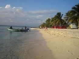
 Beata's shore | |
| Geography | |
|---|---|
| Coordinates | 17°34′42″N 71°30′42″W / 17.57833°N 71.51167°W |
| Area | 41 km2 (16 sq mi) |
| Administration | |
| Province | Pedernales Province |
| Demographics | |
| Population | 10 (2010) |
| Pop. density | 0.41/km2 (1.06/sq mi) |
Beata Island (Spanish: Isla Beata) is a small island on the Caribbean Sea, located 7 km (4 mi) southwest from Cape Beata. Some 12 km (7 mi) southwest of it lies the smaller Alto Velo Island. It is politically part of the Dominican Republic, and is roughly triangle-shaped and fairly flat, with an approximate area of 41 km2 (16 sq mi).
The island, along with Alto Velo Island, is part of the UNESCO Biosphere Reserve named the Jaragua National Park.[1]
