| Beaufortain Massif | |
|---|---|
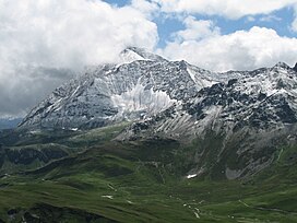
 The Pointe de la Terrasse as seen from the Rocher du Vent | |
| Highest point | |
| Elevation | 2,995 m (9,826 ft)[1] |
| Prominence | 1,028 m (3,373 ft)[1] |
| Coordinates | 45°41′10.71″N 6°34′8.63″E / 45.6863083°N 6.5690639°E[2] |
| Naming | |
| Native name | Massif du Beaufortain (French) |
| Geography | |
| Parent range | French Alps |
The Beaufortain Massif (French: Massif du Beaufortain) is a massif of the French Alps that straddles the southeastern departments of Savoie and Haute-Savoie, in the historical region of Savoy.
It is bounded by the Arly river to the northwest, the Bon Nant to the northeast, as well as the Isère river as it runs through the Tarentaise Valley to the south. It is also crossed by the Dorinet and Doron de Beaufort rivers, in addition to their tributaries, from northeast to southwest, at Beaufort level.
It is surrounded by the Aravis Range, the Bauges Range, the Lauzière massif, the Vanoise massif and the Mont-Blanc massif.
- ^ a b "Le Roignais - peakbagger.com". peakbagger.com. Retrieved 9 March 2015.
- ^ "Haute Route du Beaufortain". Savoie Mont Blanc.
