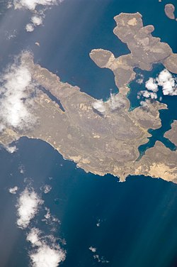
Beaver Island
Isla San Rafael | |
|---|---|
 | |
 | |
| Coordinates: 51°50′20″S 61°16′40″W / 51.83889°S 61.27778°W | |
| Country | Falkland Islands |
| Named for | English: from Beaver, a whaling ship |
| Area | |
| • Total | 48.56 km2 (18.75 sq mi) |
| Time zone | UTC−3 (FKST) |
| If shown, area and population ranks are for all islands and all inhabited islands in the Falklands respectively. | |
Beaver Island (Spanish: Isla San Rafael) is one of the Beaver Island group of Falkland Islands. It lies west of Weddell Island and south of New Island and has an area of 4,856 hectares (12,000 acres).
Other islands in the group include Staats Island, with an area of 500 hectares (1,200 acres); Tea Island, which covers 310 hectares (770 acres); Governor Island, which covers 220 hectares (540 acres); Split Island, with an area of 70 hectares (170 acres) and a few smaller islands. Though the smaller islands in the group are low-lying, the larger islands are very hilly, with many peaks of more than 150 metres (490 ft) and some more than 200 metres (660 ft). The highest elevation in the Beaver Island Group is 234 metres (768 ft).[1]
- ^ "Important Bird Areas factsheet: Beaver Island Group". BirdLife International. 2012. Retrieved 3 November 2012.