This article needs additional citations for verification. (February 2014) |
| Belaya | |
|---|---|
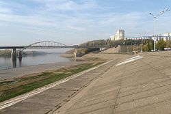
 The Belaya in Ufa | |
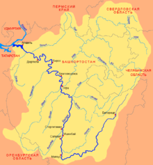
 Belaya basin | |
| Location | |
| Country | Russia |
| Region | Bashkortostan |
| Physical characteristics | |
| Source | Iremel mountains |
| • location | Novokhusainovo, Uchalinsky District |
| • coordinates | 54°33′0″N 59°3′0″E / 54.55000°N 59.05000°E |
| • elevation | 749 m (2,457 ft) |
| Mouth | Kama |
• location | Nizhnekamsk Reservoir |
• coordinates | 55°53′14″N 53°36′14″E / 55.88722°N 53.60389°E |
• elevation | 57 m (187 ft) |
| Length | 1,430 km (890 mi) |
| Basin size | 142,000 km2 (55,000 sq mi) |
| Discharge | |
| • average | 858 m3/s (30,300 cu ft/s) (near Birsk) |
| Basin features | |
| Progression | Kama→ Volga→ Caspian Sea |
 | |
The Belaya (/ˈbɛlaɪə/ BEL-y-ə)[a] is a river in Bashkortostan, Russia. Its source lies in the south-western Ural Mountains.
It is 1,430 kilometres (890 mi) long, and its drainage basin covers 142,000 square kilometres (55,000 sq mi).[1][2]
Settlements along the Belaya include Beloretsk, Sterlitamak, Ufa (at the confluence with the river Ufa), and Birsk. The Belaya flows into the Kama near Neftekamsk.
Cite error: There are <ref group=lower-alpha> tags or {{efn}} templates on this page, but the references will not show without a {{reflist|group=lower-alpha}} template or {{notelist}} template (see the help page).
- ^ «Река БЕЛАЯ», Russian State Water Registry
- ^ "Belaya River". Britannica.com. Retrieved 30 May 2016.
