You can help expand this article with text translated from the corresponding article in French. (December 2008) Click [show] for important translation instructions.
|
Belcastel
Bèlcastèl (Occitan) | |
|---|---|
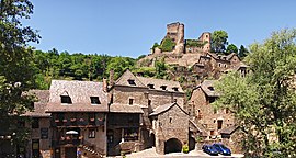
 A view of Belcastel | |
| Coordinates: 44°23′22″N 2°20′16″E / 44.3894°N 2.3378°E | |
| Country | France |
| Region | Occitania |
| Department | Aveyron |
| Arrondissement | Villefranche-de-Rouergue |
| Canton | Enne et Alzou |
| Intercommunality | Pays Rignacois |
| Government | |
| • Mayor (2020–2026) | Jean-Louis Bessiere[1] |
| Area 1 | 10.74 km2 (4.15 sq mi) |
| Population (2021)[2] | 192 |
| • Density | 18/km2 (46/sq mi) |
| Time zone | UTC+01:00 (CET) |
| • Summer (DST) | UTC+02:00 (CEST) |
| INSEE/Postal code | 12024 /12390 |
| Elevation | 391–707 m (1,283–2,320 ft) (avg. 450 m or 1,480 ft) |
| 1 French Land Register data, which excludes lakes, ponds, glaciers > 1 km2 (0.386 sq mi or 247 acres) and river estuaries. | |
Belcastel (French pronunciation: [bɛlkastɛl]; Occitan: Bèlcastèl) is a commune in the Aveyron department in the Occitania region in Southern France.
The village is medieval in character, with cobbled streets and lauze-roofed (stone tiled) houses. The bulk of the village and the castle (Château de Belcastel) are situated on the steep north bank of the river Aveyron. Several buildings including the 15th-century church are on the south side of the river, with a similarly aged bridge connecting the two.
A ruined fort, the Fort du Lourdou, can also be found about a kilometre west of the village on the south bank of the river at the Roc d'Anglars. Belcastel was nominated as one of the "most beautiful villages of France" (Les Plus Beaux Villages de France) in 1990; the local council regularly hosts watercolour competitions and art exhibitions during the summer.
- ^ "Répertoire national des élus: les maires". data.gouv.fr, Plateforme ouverte des données publiques françaises (in French). 9 August 2021.
- ^ "Populations légales 2021" (in French). The National Institute of Statistics and Economic Studies. 28 December 2023.


