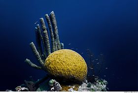
| Belize Barrier Reef | |
|---|---|
 The Barrier Reef is clearly visible along the eastern coast of Belize in the Caribbean Sea. | |
| Location | Belize |
| Nearest city | Belize City, Belize |
| Coordinates | 17°18′56″N 87°32′4″W / 17.31556°N 87.53444°W |
| Official name | Belize Barrier Reef Reserve System |
| Type | Natural |
| Criteria | vii, ix, x |
| Designated | 1996 (20th session) |
| Reference no. | 764 |
| Region | Latin America and the Caribbean |
| Endangered | 2009–2018 |

The Belize Barrier Reef is a series of coral reefs straddling the coast of Belize, roughly 300 metres (980 ft) offshore in the north and 40 kilometres (25 mi) in the south within the country limits. The Belize Barrier Reef is a 300-kilometre (190 mi) long section of the 900-kilometre (560 mi) Mesoamerican Barrier Reef System, which is continuous from Cancún on the north-eastern tip of the Yucatán Peninsula through the Riviera Maya and down to Honduras, making it the second largest coral reef system in the world after the Great Barrier Reef in Australia. It is Belize's top tourist destination, popular for scuba diving and snorkeling and attracting almost half of its 260,000 visitors. It is also vital to the country's fishing industry.[1]
Charles Darwin described it as "the most remarkable reef in the West Indies" in 1842.
In addition to its barrier reef, it also boasts three distinct Caribbean atolls: Turneffe Atoll, Glover's Reef and Lighthouse Reef. Lighthouse Reef is the most easterly diving area in Belize, it is home to the Great Blue Hole, made famous by Jacques Cousteau in 1970; Turneffe Atoll lies directly to the east of Belize City and is the nearest of the atolls to that city. These different reefs provide diverse scuba diving opportunities that include walls, pinnacles and reef flats that are located throughout an enormous area of sea.[2]
- ^ Harrabin, Roger. (2006-06-12) Reef at forefront of CO2 battle . BBC News. Retrieved on 2011-10-21.
- ^ "Scuba Diving in Belize: The Blue Hole, Ambergris and Turneffe Atoll". dive-the-world.com.

