Bella Vista | |
|---|---|
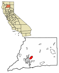
 Location of Bella Vista in Shasta County, California | |
| Coordinates: 40°39′06″N 122°15′23″W / 40.65167°N 122.25639°W | |
| Country | |
| State | |
| County | Shasta |
| Area | |
| • Total | 26.64 sq mi (68.99 km2) |
| • Land | 26.44 sq mi (68.49 km2) |
| • Water | 0.20 sq mi (0.51 km2) 0.64% |
| Elevation | 656 ft (200 m) |
| Population (2020) | |
| • Total | 3,641 |
| • Density | 137.70/sq mi (53.16/km2) |
| Time zone | UTC-8 (Pacific (PST)) |
| • Summer (DST) | UTC-7 (PDT) |
| ZIP Code | 96008 |
| GNIS feature ID | 2582942 |
| U.S. Geological Survey Geographic Names Information System: Bella Vista, California | |
Bella Vista (Spanish for "Beautiful View") is a census-designated place (CDP) in Shasta County, California.[2] Bella Vista is a small, rural community about 9 miles (14 km) northeast of Redding, and about 5 miles (8.0 km) north of Palo Cedro. Its population is 3,641 as of the 2020 census, up from 2,781 from the 2010 census. Historically, Bella Vista was a semi-large lumber town which hosted its own railroad.
- ^ "2020 U.S. Gazetteer Files". United States Census Bureau. Retrieved October 30, 2021.
- ^ a b U.S. Geological Survey Geographic Names Information System: Bella Vista, California
