| Belle Isle Park | |
|---|---|
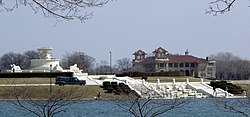
 James Scott Memorial Fountain, with the Belle Isle Casino in the background | |
| Type | State park |
| Location | Detroit, Michigan, U.S. |
| Coordinates | 42°20′25″N 82°59′12″W / 42.34028°N 82.98667°W |
| Area | 982 acres (397 ha) |
| Created | 1845 (2014 as a state park)[1] |
| Operated by | State of Michigan |
| Website | www |
Belle Isle | |
| Location | Detroit River |
| Architect | Frederick Law Olmsted |
| NRHP reference No. | 74000999[2] |
| Added to NRHP | February 25, 1974 |
Belle Isle Park, known simply as Belle Isle (/bɛlˈaɪəl/), is a 982-acre (1.534 sq mi; 397 ha) island park in Detroit, Michigan, developed in the late 19th century. It consists of Belle Isle, an island in the Detroit River, as well as several surrounding islets. The U.S.-Canada border is in the channel south of Belle Isle.
Owned by the city of Detroit, Belle Isle is managed as a state park by the Michigan Department of Natural Resources through a 30-year lease initiated in 2013; it was previously a city park.[1] Belle Isle Park is the largest city-owned island park in the United States, and Belle Isle is the third largest island in the Detroit River, after Grosse Ile and Fighting Island. It is connected to mainland Detroit by the MacArthur Bridge.
Belle Isle Park is home to the Belle Isle Aquarium, the Belle Isle Conservatory, the Belle Isle Nature Center, the James Scott Memorial Fountain, the Dossin Great Lakes Museum, a municipal golf course, a half-mile (800 m) swimming beach, and numerous other monuments and attractions. It is also the site of a Coast Guard station. The Detroit Yacht Club is located on an adjacent island, connected to Belle Isle by a bridge.
- ^ a b "Belle Isle becomes a state park today, improvements continue" (Press release). Michigan Department of Natural Resources. February 10, 2014. Archived from the original on May 12, 2014. Retrieved May 8, 2014.
- ^ "National Register Information System". National Register of Historic Places. National Park Service. March 13, 2009.

