Belle Vernon, Pennsylvania | |
|---|---|
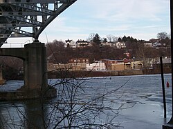
 Belle Vernon, as seen from across the Monongahela River in a view showing the underside of the I-70 bridge looking east-north-east from Speers | |
 Location of Belle Vernon in Fayette County, Pennsylvania. | |
 Location of Pennsylvania in the United States | |
| Coordinates: 40°7′37″N 79°52′6″W / 40.12694°N 79.86833°W | |
| Country | United States |
| State | Pennsylvania |
| County | Fayette |
| Established | 1813 |
| Government _Mayor - Gerald W. Jackson II | |
| Area | |
| • Total | 0.33 sq mi (0.85 km2) |
| • Land | 0.26 sq mi (0.68 km2) |
| • Water | 0.07 sq mi (0.18 km2) |
| Highest elevation | 1,080 ft (330 m) |
| Lowest elevation | 738 ft (225 m) |
| Population | |
| • Total | 1,024 |
| • Density | 3,923.37/sq mi (1,513.80/km2) |
| Time zone | UTC-4 (EST) |
| • Summer (DST) | UTC-5 (EDT) |
| ZIP code | 15012[3] |
| Area code | 724 |
| FIPS code | 42-05288 |
Belle Vernon is a borough in Fayette County, Pennsylvania, United States. It is situated along the Monongahela River, abutting two other counties, Westmoreland to the north and Washington across the river. As of the 2020 census, Belle Vernon had a population of 1,025.[4]
"Bellevernon", as it was originally spelled, was laid out in 1813 by Noah Speers in northwestern Fayette County. French for "beautiful green", this was the name chosen by both Noah Speers for his little community on the Monongahela River and later by his son Louis, who founded a town with nearly the same name just up the hill (North Belle Vernon). Directly across the river lies the borough of Speers, anchoring the far side of the landmark I-70 bridge as the east bridge abutments lie in adjacent Rostraver Township.
- ^ "ArcGIS REST Services Directory". United States Census Bureau. Retrieved October 12, 2022.
- ^ Cite error: The named reference
USCensusDecennial2020CenPopScriptOnlywas invoked but never defined (see the help page). - ^ "Belle Vernon PA ZIP Code". zipdatamaps.com. 2023. Retrieved June 27, 2023.
- ^ Bureau, US Census. "City and Town Population Totals: 2020—2021". Census.gov. US Census Bureau. Retrieved July 24, 2022.
{{cite web}}:|last1=has generic name (help)