| Bellenden Ker | |
|---|---|
| Wooroonooran | |
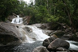
 Josephine Falls in Wooroonooran National Park. | |
| Highest point | |
| Peak | Mount Bartle Frere |
| Elevation | 1,622 m (5,322 ft) |
| Geography | |
 | |
| Country | Australia |
| State | Queensland |
| Region | Far North Queensland |
| Range coordinates | 17°14′S 145°52′E / 17.233°S 145.867°E |
| Parent range | Great Dividing Range |
The Bellenden Ker Range, also known as the Wooroonooran Range is a coastal mountain range in Far North Queensland, Australia.[1] Part of the Great Dividing Range it is located between Gordonvale and Babinda.
The whole of the range falls within the Wet Tropics World Heritage Area[2] and is covered in richly diverse world heritage listed wet tropical forests, including species of flora and fauna endemic to the range. The range also forms part of the Wooroonooran Important Bird Area, identified as such by BirdLife International because it supports populations of a range of bird species endemic to Queensland's Wet Tropics.[3] Most of the range is also a gazetted protected area named Wooroonooran National Park.
Queensland's two highest mountains, Mount Bartle Frere (1622 m) and Mount Bellenden Ker (1593 m) form part of this range, and Walshs Pyramid (922 m) (one of the highest free-standing natural pyramids in the world) is located at the range's northern end [citation needed].
- ^ "Bellenden Ker Range (entry 2184)". Queensland Place Names. Queensland Government. Retrieved 21 June 2017.
- ^ "Wet Tropics Management Authority World Heritage Area maps". Archived from the original on 12 September 2009. Retrieved 11 May 2018.
- ^ "Important Bird Areas factsheet: Wooroonooran". BirdLife International. 2011. Archived from the original on 11 May 2018. Retrieved 11 May 2018.