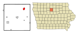
Belmond, Iowa | |
|---|---|
 Location of Belmond, Iowa | |
| Coordinates: 42°50′50″N 93°36′44″W / 42.84722°N 93.61222°W | |
| Country | |
| State | |
| County | Wright |
| Incorporated | October 21, 1881[1] |
| Area | |
| • Total | 2.83 sq mi (7.34 km2) |
| • Land | 2.83 sq mi (7.34 km2) |
| • Water | 0.00 sq mi (0.00 km2) |
| Elevation | 1,178 ft (359 m) |
| Population (2020) | |
| • Total | 2,463 |
| • Density | 869.40/sq mi (335.72/km2) |
| Time zone | UTC-6 (Central (CST)) |
| • Summer (DST) | UTC-5 (CDT) |
| ZIP code | 50421 |
| Area code | 641 |
| FIPS code | 19-05680 |
| GNIS feature ID | 0454502 |
Belmond is a city in Wright County, Iowa, United States. It is located along U.S. Route 69, 14 miles (23 km) by road from Clarion, the county seat. The population was 2,463 in the 2020 census, a decline from 2,560 in 2000.[3]
- ^ "Belmond-Iowa". City-Data. Retrieved April 21, 2011.
- ^ "2020 U.S. Gazetteer Files". United States Census Bureau. Retrieved March 16, 2022.
- ^ "2020 Census State Redistricting Data". census.gov. United states Census Bureau. Retrieved August 12, 2021.
