| Belsay | |
|---|---|
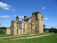
 Belsay Castle | |
Location within Northumberland | |
| Population | 436 (2001)[1] |
| OS grid reference | NZ101786 |
| Civil parish |
|
| Unitary authority | |
| Ceremonial county | |
| Region | |
| Country | England |
| Sovereign state | United Kingdom |
| Post town | Newcastle Upon Tyne |
| Postcode district | NE20 |
| Dialling code | 01661 |
| Police | Northumbria |
| Fire | Northumberland |
| Ambulance | North East |
| UK Parliament | |
Belsay is a village and civil parish in Northumberland, England. The village is about 5 miles (10 km) from Ponteland on the A696, which links the village with Newcastle upon Tyne and Jedburgh. The population of the civil parish was 436 at the 2001 census, increasing to 518 at the 2011 Census.[2]
Scottish nobleman and doctor, John de Strivelyn, was granted the manor around 1340 by Edward III. On his death, the estate passed to his daughter Christiana, who was married to Sir John Middleton, and it has remained with the Middleton family ever since.
Belsay was formerly a township in the parish of Bolam,[3] in 1866 Belsay became a civil parish. Belsay parish includes the former parishes of Bitchfield, Black Heddon, Bolam, Bolam Vicarage, Bradford, Gallowhill, Harnham, Newham, Shortflatt, Trewick, and Wallridge[4] which were merged with Belsay on 1 April 1955.[5]
Belsay is home to Belsay Castle, a fine medieval castle, and to Belsay Hall.
- ^ "Office for National Statistics: Neighbourhood Statistics". Archived from the original on 22 October 2013. Retrieved 25 October 2009.
- ^ "Civil Parish population 2011". Archived from the original on 11 March 2016. Retrieved 28 January 2016.
- ^ "History of Belsay, in Castle Morpeth and Northumberland". A Vision of Britain through Time. Retrieved 21 November 2023.
- ^ "Ordnance Survey Maps of England and Wales - Revised, Northumberland". Archived from the original on 10 July 2020.
- ^ "Relationships and changes Belsay CP/Tn through time". A Vision of Britain through Time. Retrieved 21 November 2023.
