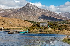
| Benlettery | |
|---|---|
| Binn Leitrí | |
 Benlettery behind the Ballynahinch Castle fishery | |
| Highest point | |
| Elevation | 577 m (1,893 ft)[1] |
| Prominence | 62 m (203 ft)[1] |
| Listing | Arderin |
| Coordinates | 53°28′55″N 9°50′43″W / 53.481824°N 9.845263°W[1] |
| Naming | |
| English translation | Peak of the Wet Hillsides |
| Language of name | Irish |
| Geography | |
| Location | County Galway, Ireland |
| Parent range | Twelve Bens |
| OSI/OSNI grid | L7754649537 |
| Topo map | OSi Discovery 44 |
| Geology | |
| Rock type(s) | Pale quartzites, grits, graphitic bedrock[1] |
Benlettery (Irish: Binn Leitrí, meaning 'Peak of the Wet Hillsides')[2] at 557 metres (1,827 ft), is the 259th–highest peak in Ireland on the Arderin scale.[3][4][5] Benlettery is in the southernmost peak of the Twelve Bens mountain range in the Connemara National Park in County Galway, Ireland, and is the 11th-tallest of the core Twelve Bens.[5][6] The Ben Lettery An Oige youth hostel is on the southern slopes of Benlettery, off the N59 road to Clifden.[7][8]
- ^ a b c d "Benlettery". MountainViews Online Database. Retrieved 31 July 2019.
- ^ Paul Tempan (February 2012). "Irish Hill and Mountain Names" (PDF). MountainViews.ie.
- ^ Simon Stewart (October 2018). "Arderins: Irish mountains of 500+m with a prominence of 30m". MountainViews Online Database.
- ^ Simon Stewart (October 2018). "Vandeleur-Lynams: Irish mountains of 600+m with a prominence of 15m". MountainViews Online Database.
- ^ a b Mountainviews, (September 2013), "A Guide to Ireland's Mountain Summits: The Vandeleur-Lynams & the Arderins", Collins Books, Cork, ISBN 978-1-84889-164-7
- ^ Dillion, Paddy (2001). Connemara: Collins Rambler's guide. Harper Collins. ISBN 978-0002201216.
- ^ "Ben Lettery Youth Hostel". An Oige, Irish Youth Hostel Association. Retrieved 9 August 2019.
- ^ Cite error: The named reference
lpwas invoked but never defined (see the help page).
