This article needs additional citations for verification. (June 2008) |

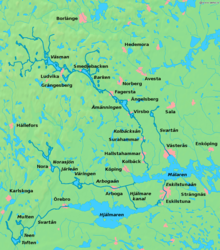
Bergslagen is a historical,[citation needed] cultural,[citation needed] and linguistic[1] region located north of Lake Mälaren in northern Svealand, Sweden, traditionally known as a mining district.[2] In Bergslagen, the mining and metallurgic industries have been important since the Middle Ages although Malmfälten ("the Ore Fields"), the mining district of northernmost Sweden centred at the towns of Kiruna and Malmberget, has been of greater importance during the 20th century.
Bergslagen is not precisely defined, but generally understood to cover part of the provinces of Västmanland, Dalarna (the southern part), and Värmland (the eastern part). Typical towns in the area include Lindesberg,[3][4] Nora, Fagersta, Sala, Kristinehamn, Filipstad, Grythyttan, Ludvika and Hedemora. Also parts of northern Östergötland, around Finspång, as well as southern Närke can be included, then often referring to South Bergslagen. A wider definition of the area can include parts of Gästrikland (Hofors) and Uppland (the former iron manufacturing district centred on Dannemora) as well.
- ^ Josephson, Olle (30 June 2014). "Håll koll på diftongerna i sommar!". Svenska Dagbladet (in Swedish). Schibsted. Retrieved 13 December 2014.
Bergslagstal ("Bergslagen speech")
- ^ "Vår historia - Bergslagen.se". www.bergslagen.se (in Swedish). Retrieved 2019-10-09.
- ^ "Fakta om kommunen". www.lindesberg.se (in Swedish). Retrieved 2019-10-09.
- ^ "Vår historia - Bergslagen.se". www.bergslagen.se (in Swedish). Retrieved 2019-10-09. [verification needed]