| Bering Sea | |
|---|---|
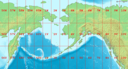
 Map showing the location of the Bering Sea with latitude and longitude zones of the Universal Transverse Mercator coordinate system | |
| Coordinates | 58°0′N 178°0′W / 58.000°N 178.000°W |
| Basin countries | Russia and United States |
| Surface area | 2,000,000 km2 (770,000 sq mi) |
The Bering Sea (/ˈbɛərɪŋ, ˈbɛrɪŋ/ BAIR-ing, BERR-ing, US also /ˈbɪərɪŋ/ BEER-ing;[1][2][3] Russian: Бе́рингово мо́ре, romanized: Béringovo móre, IPA: [ˈbʲerʲɪnɡəvə ˈmorʲe]) is a marginal sea of the Northern Pacific Ocean. It forms, along with the Bering Strait, the divide between the two largest landmasses on Earth: Eurasia and the Americas.[4][5] It comprises a deep water basin, which then rises through a narrow slope into the shallower water above the continental shelves. The Bering Sea is named after Vitus Bering, a Danish-born Russian navigator, who, in 1728, was the first European to systematically explore it, sailing from the Pacific Ocean northward to the Arctic Ocean.[6]
The Bering Sea is separated from the Gulf of Alaska by the Alaska Peninsula. It covers over 2,000,000 square kilometers (770,000 sq mi) and is bordered on the east and northeast by Alaska, on the west by the Russian Far East and the Kamchatka Peninsula, on the south by the Alaska Peninsula and the Aleutian Islands and on the far north by the Bering Strait, which connects the Bering Sea to the Arctic Ocean's Chukchi Sea.[7] Bristol Bay is the portion of the Bering Sea between the Alaska Peninsula and Cape Newenham on mainland Southwest Alaska.
The Bering Sea ecosystem includes resources within the jurisdiction of the United States and Russia, as well as international waters in the middle of the sea (known as the "Donut Hole"[8]). The interaction between currents, sea ice, and weather makes for a vigorous and productive ecosystem.
- ^ Jones, Daniel (2011). Roach, Peter; Setter, Jane; Esling, John (eds.). Cambridge English Pronouncing Dictionary (18th ed.). Cambridge University Press. ISBN 978-0-521-15255-6.
- ^ Wells, John C. (2008). Longman Pronunciation Dictionary (3rd ed.). Longman. ISBN 978-1-4058-8118-0.
- ^ "Bering". Merriam-Webster.com Dictionary. Merriam-Webster. Retrieved 19 September 2020.
- ^ Fasham, M. J. R. (2003). Ocean biogeochemistry: the role of the ocean carbon cycle in global change. Springer. p. 79. ISBN 978-3-540-42398-0.
- ^ McColl, R.W. (2005). Encyclopedia of World Geography. Infobase Publishing. p. 697. ISBN 978-0-8160-5786-3. Retrieved 26 November 2010.
- ^ "Vitus Bering". Encyclopaedia Britannica. Retrieved 2018-12-21.
- ^ "Area of Bering sea". Encyclopaedia Britannica. Retrieved 2018-12-21.
- ^ "North Pacific Overfishing (DONUT)". Trade Environment Database. American University. Archived from the original on 9 April 2011. Retrieved 13 August 2011.
