באר שבע | |
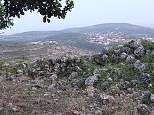
 View from atop of Bersabe (Khirbet Abu esh-Sheba) | |
| Alternative name | Beer Sheba of the Galilee; Khirbet Beersheba |
|---|---|
| Location | Galilee |
| Region | between Upper and Lower Galilee |
| Coordinates | 32°55′23″N 35°25′07″E / 32.92306°N 35.41861°E |
| History | |
| Periods | Iron Age, Persian, Hellenistic, Roman, Byzantine, Arab |
| Cultures | Jewish, Greco-Roman |
| Site notes | |
| Excavation dates | 1976, 1985, 2000, 2004 |
| Archaeologists | Mordechai Aviam, Oren Tal – Y. Tepper – Alexander Fantalkin, Uzi Leibner |
| Condition | Ruin |
Bersabe (Hebrew: בְּאֵר שֶׁבַע, romanized: Bəʾēr Ševaʿ; Ancient Greek: Βηρσαβέ, romanized: Bērsabé, or Βηρσουβαί, Bērsoubaí), also known as Beersheba of Galilee,[1] was a Second Temple period Jewish village located near the town of Kefar Hananya which marked the boundary between the Upper Galilee and the Lower Galilee, as described by Josephus,[2][3] with Upper Galilee stretching from Bersabe in the Beit HaKerem Valley to Baca (Peki'in) in the north. Bersabe was one of several towns and villages of Galilee fortified by Josephus during the First Jewish–Roman War,[4][5] being one of the most defensible positions[6] and where insurgents from across Galilee had taken up refuge against the Imperial Roman army when the surrounding countryside was plundered.[7]
The ancient village has been identified with the present site of Khirbet es-Saba, a hilltop ruin within a distance of less than a kilometer of the village Kafr 'Inan (Kefr ʿAnan), at the eastern fringe of the Beit HaKerem Valley, and rising some 472 metres (1,549 ft) above sea-level.[8] The same site has been rendered by other authors under the name Khirbet Abu esh-Shebaʿ, a little northwest of Kefr ʿAnan and closely adjoining Farradiyya/Parod to their southwest.[9][10] The site lies 5 kilometres (3.1 mi) eastward of the Arab town of er-Rameh, along Route 85, and about 8 kilometres (5.0 mi) southwest of Safed.
In 1873, Kitchener and Conder, on a surveying mission with the Palestine Exploration Fund, visited the site and mentioned it as being "a large ruin, which stands upon the terraced hill top."[11] A survey later conducted at the site reveal that the village had occupied an area of about 70 dunams (17.3 acres).[12]
From a prospect on Mount Kefir in the Mount Meron range, as one looks out over the hilltop ruin of Bersabe, the square layout or lines where once stood the walls of the town can still be distinguished.[13] The line of the ancient wall extended over an area comprising the upper third of the hill.[12] The thickness of the northernmost wall, where the hill was easily accessible, is measured at 2.8 metres (9.2 ft), and was built with three semi-circular watch towers. The easternmost wall was built in a zig-zag configuration. The walls were constructed of fieldstones.
- ^ "LXVII. Beersheba (Galilee)", Volume 5/Part 1 Galilaea and Northern Regions: 5876-6924, De Gruyter, pp. 372–373, 2023-03-20, doi:10.1515/9783110715774-075, ISBN 978-3-11-071577-4, retrieved 2024-02-07
- ^ Josephus, Vita 188
- ^ Josephus, De Bello Judaico (The Jewish War) II, 572; III, 35 (Wars of the Jews 3.3.1)
- ^ Josephus, Vita § 37
- ^ Rogers, Guy MacLean (2021). For the Freedom of Zion: the Great Revolt of Jews against Romans, 66-74 CE. New Haven: Yale University Press. p. 534. ISBN 978-0-300-24813-5.
- ^ Josephus, De Bello Judaico (The Jewish War) II, 572 (Wars of the Jews 2.20.6)
- ^ Josephus, De Bello Judaico (The Jewish War) III, 59 (The Jewish War 3.4.1); III, 110 (ibid. 3.6.1)
- ^ Mason, S. (2001), pp. 179; 182
- ^ Avi-Yonah, M. (1953), p. 95
- ^ Thomsen, P. (1966), p. 43
- ^ Conder & Kitchener (1881), p. 235.
- ^ a b Aviam (2008), p. 41
- ^ Aviam, M. (1983), p. 38
