Bertioga | |
|---|---|
| Municipality of Bertioga | |
 | |
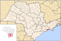
 Location in São Paulo | |
| Coordinates: 23°51′17″S 46°08′20″W / 23.85472°S 46.13889°W | |
| Country | |
| Region | Southeast |
| State | |
| Metropolitan Region | Baixada Santista |
| Government | |
| • Mayor | Caio Arias Matheus |
| Area | |
| • Total | 490.15 km2 (189.25 sq mi) |
| Elevation | 8 m (26 ft) |
| Population (2020)[1] | |
| • Total | 64,723 |
| • Density | 130/km2 (340/sq mi) |
| Time zone | UTC−3 (BRT) |
| HDI (2010) | 0.730 – high[2] |
| Website | bertioga |
Bertioga is a Brazilian municipality in the state of São Paulo and part of the Baixada Santista Metropolitan Region.[3] Its population is 64,723 (2020 est.) in an area of 490.15 km2.[4] Because it neighbors resort towns, its population fluctuates greatly with the seasons. The more northern parts are densely forested and humanly unpopulated. It was created on 19 May 1991, from a part of Santos.
The municipality contains the 9,312 hectares (23,010 acres) Restinga de Bertioga State Park, created in 2010 to protect an area of mangroves, restinga and rainforest.[5] Its limits are Mogi das Cruzes, Biritiba-Mirim and Salesópolis in the north, São Sebastião in the east, Atlantic Ocean to the south with Ilha de Santo Amaro (opposite the city) and Santos in the west.
Bertioga is where Josef Mengele, a Nazi doctor at Auschwitz, drowned in 1979.[6]
- ^ IBGE 2020
- ^ "Archived copy" (PDF). United Nations Development Programme (UNDP). Archived from the original (PDF) on July 8, 2014. Retrieved August 1, 2013.
{{cite web}}: CS1 maint: archived copy as title (link) - ^ Assembleia Legislativa do Estado de São Paulo, Lei Complementar Nº 815
- ^ Instituto Brasileiro de Geografia e Estatística
- ^ Parque Estadual Restinga de Bertioga (in Portuguese), Fundação Florestal - Governo do Estado de São Paulo, retrieved 2017-01-17
- ^ Gibson, Kenneth (31 March 2012). Killer Doctors: The Ultimate Betrayal of Trust. Neil Wilson Publishing. p. 132. ISBN 978-1-906476-59-5.

