Bethulie | |
|---|---|
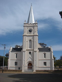
 Nederduitse Gereformeerde Church, Grey Street, Bethulie | |
| Coordinates: 30°28′S 25°58′E / 30.467°S 25.967°E | |
| Country | South Africa |
| Province | Free State |
| District | Xhariep |
| Municipality | Kopanong |
| Established | 1863[1] |
| Government | |
| • Type | Municipality |
| • Mayor | Xolile Mathwa[2] (ANC) |
| Area | |
| • Total | 37.0 km2 (14.3 sq mi) |
| Population (2023)[3] | |
| • Total | +−16,000 |
| • Density | −430/km2 (−1,100/sq mi) |
| Racial makeup (2011) | |
| • Black African | 81.6% |
| • Coloured | 9.3% |
| • Indian/Asian | 0.7% |
| • White | 8.0% |
| • Other | 0.4% |
| First languages (2011) | |
| • Xhosa | 43.8% |
| • Sotho | 31.0% |
| • Afrikaans | 18.9% |
| • English | 2.7% |
| • Other | 3.7% |
| Time zone | UTC+2 (SAST) |
| Postal code (street) | 9992 |
| PO box | 9992 |
| Area code | 051 |
Bethulie is a small sheep and cattle farming town in the Free State province of South Africa. The name meaning chosen by God was given by directors of a mission station in 1829 which the town formed around. The mission building is the oldest settler built building still standing in the Free State. The town was also home to one of the largest concentration camps run by the British during the Boer War. The Dutch Reformed Church was built in 1862.
- ^ Robson, Linda Gillian (2011). "Annexure A" (PDF). The Royal Engineers and settlement planning in the Cape Colony 1806–1872: Approach, methodology and impact (PhD thesis). University of Pretoria. pp. xlv–lii. hdl:2263/26503.
- ^ Free State Tourism.org Archived January 6, 2014, at the Wayback Machine
- ^ a b c d Sum of the Main Places Bethulie and Lephoi from Census 2011.


