Betterton, Maryland | |
|---|---|
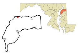
 Location of Betterton, Maryland | |
| Coordinates: 39°22′4″N 76°3′39″W / 39.36778°N 76.06083°W | |
| Country | |
| State | |
| County | |
| Incorporated | 1906[1] |
| Government | |
| • Type | Mayor-Council |
| • Mayor | Donald E. Sutton |
| Area | |
| • Total | 1.00 sq mi (2.58 km2) |
| • Land | 0.99 sq mi (2.56 km2) |
| • Water | 0.01 sq mi (0.02 km2) |
| Elevation | 72 ft (22 m) |
| Population (2020) | |
| • Total | 286 |
| • Density | 288.89/sq mi (111.54/km2) |
| Time zone | UTC-5 (Eastern (EST)) |
| • Summer (DST) | UTC-4 (EDT) |
| ZIP code | 21610 |
| Area code | 410 |
| FIPS code | 24-07200 |
| GNIS feature ID | 0583196 |
| Website | townofbetterton.com |
Betterton Historic District | |
 Rigbie Hotel | |
| Location | Roughly bounded by Sassafras River, Gut Marsh, 6th, and Ericsson Aves., Betterton, Maryland |
|---|---|
| Coordinates | 39°22′2″N 76°3′47″W / 39.36722°N 76.06306°W |
| Built | 1880 |
| Architectural style | Gothic |
| NRHP reference No. | 84001805 [3] |
| Added to NRHP | June 7, 1984 |
Betterton is a town in Kent County, Maryland, United States. The population was 345 at the 2010 census.
- ^ "Betterton". Maryland Manual. Retrieved June 26, 2017.
- ^ "2020 U.S. Gazetteer Files". United States Census Bureau. Retrieved April 26, 2022.
- ^ "National Register Information System". National Register of Historic Places. National Park Service. April 15, 2008.


