Bharuch district | |
|---|---|
 Location of Bharuch district in Gujarat | |
| Coordinates: 20°42′N 72°59′E / 20.700°N 72.983°E | |
| Country | |
| State | Gujarat |
| Headquarters | Bharuch |
| Area | |
| • Total | 6,509 km2 (2,513 sq mi) |
| Population (2011) | |
| • Total | 1,551,019 |
| • Density | 240/km2 (620/sq mi) |
| Languages | |
| • Official | Gujarati, Hindi, English |
| Time zone | UTC+5:30 (IST) |
| Vehicle registration | GJ-16 |
| Website | bharuch |
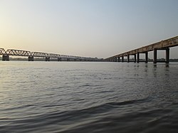
Bharuch (formerly commonly known as Broach) in India, is a district in the southern part of the Kathiawar peninsula on the west coast of state of Gujarat with a size and population comparable to that of Greater Boston. Bharuch derives its name from the famous Hindu sage Bhrigu. A historical name for Bharuch is 'Bhrigukachchha'. The mythological Bhrigu Rishi was said to be one of the ten sons of Brahma. There is also a story which indicates that Bhrigu along with his kin asked for temporary access to Bharuch which was said to belong to Lakshmi, since Bharuch is located on the banks of river Narmada also known as Rudra Deha. Chanra Mauli Mahadev is the Hindu Kul Devata of Bhargavs of Bharuch. Bhrigu never left the place and the Ashram of Brighu Rishi is located on the banks of Narmada. The Narmada River outlets into the Gulf of Khambat through its lands and that shipping artery gave inland access to the kingdoms and empires located in the central and northern parts of the sub-continent of India.


