Bhor State भोर संस्थान | |||||||||
|---|---|---|---|---|---|---|---|---|---|
| 1697–1948 | |||||||||
|
Flag | |||||||||
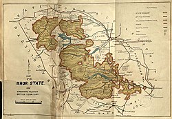
 Map of Bhor State, 1930 | |||||||||
| History | |||||||||
• Established | 1697 | ||||||||
| 1948 | |||||||||
| Area | |||||||||
| 1901 | 2,396 km2 (925 sq mi) | ||||||||
| Population | |||||||||
• 1901 | 137,268 | ||||||||
| |||||||||
| Today part of | Maharashtra, India | ||||||||
This article incorporates text from a publication now in the public domain: Chisholm, Hugh, ed. (1911). "Bhor". Encyclopædia Britannica (11th ed.). Cambridge University Press. | |||||||||

Bhor State was one of the 9-gun salute Maratha princely states of Deccan States Agency. It was the only state belonging to the Poona Agency under the Bombay Presidency, which became later part of the Deccan States Agency. Along with Akkalkot State, Aundh State, Phaltan State and Jath State, it was one of the Satara Jagirs. The state merged with the newly independent Indian union in 1948.
Situated among the eastern slopes of the Western Ghats, the state covered an area of 2,396 square kilometres, and had a population of 137,268 in 1901.[1]
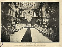
The town of Bhor, once the capital of the state, is located in the state of Maharashtra, about 51 kilometres south of Pune, adjacent to Bhatghar Dam. Lord Rama is the family deity of the Gandekars, the former rulers of the state. The seal of the state had images of Sita, Rama and Lakshmana. Every year Ramanavami is celebrated with pomp and grandeur at Bhor Rajwada, the palace of the royal family.[2]
- ^ Bhor Princely State (9 gun salute). members.iinet.net.au.
- ^ Ranade 1951, p. 182.
