| Big Muddy River | |
|---|---|
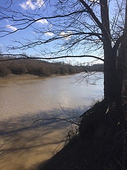
 The Big Muddy River, south of Murphysboro, at a boat launch across from the Little Grand Canyon | |
 | |
| Physical characteristics | |
| Source | |
| • location | Jefferson County southeast of Centralia, Illinois |
| • coordinates | 38°28′27″N 89°05′25″W / 38.474216°N 89.0903471°W |
| Mouth | |
• location | Confluence with the Mississippi River southwest of Murphysboro, Illinois |
• coordinates | 37°34′25″N 89°31′01″W / 37.5736608°N 89.5170413°W |
• elevation | 341 ft (104 m) |
| Length | 156 mi (251 km) |
| Discharge | |
| • location | Murphysboro, Illinois |
| • average | 2,164 cu/ft. per sec.[1] |
| Basin features | |
| Progression | Big Muddy River → Mississippi → Gulf of Mexico |
| GNIS ID | 404425 |
The Big Muddy River is a 156-mile-long (251 km) river in southern Illinois.[2] It joins the Mississippi River just south of Grand Tower. The Big Muddy has been dammed near Benton, forming Rend Lake.
The Big Muddy has a mud bottom for most of its length.