You can help expand this article with text translated from the corresponding article in Ukrainian. (July 2022) Click [show] for important translation instructions.
|
Bilhorod-Dnistrovskyi
Білгород-Дністровський Cetatea Albă | |
|---|---|
| Coordinates: 46°11′N 30°21′E / 46.183°N 30.350°E | |
| Country | |
| Oblast | Odesa Oblast |
| Raion | Bilhorod-Dnistrovskyi Raion |
| Hromada | Bilhorod-Dnistrovskyi urban hromada |
| Area | |
| • Total | 31 km2 (12 sq mi) |
| Elevation | 28 m (92 ft) |
| Population (2022)[1] | |
| • Total | 47,727 |
| Time zone | UTC+2 (EET) |
| • Summer (DST) | UTC+3 (EEST) |
| Postal code | 67700—67719 |
| Area code | +380 4849 |
| Climate | Cfb |
| Website | https://bilgorod-d.gov.ua/ |
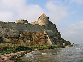
Bilhorod-Dnistrovskyi (Ukrainian: Білгород-Дністровський, IPA: [ˈb⁽ʲ⁾iɫɦorod d⁽ʲ⁾n⁽ʲ⁾iˈstrɔu̯sʲkɪj]; Romanian: Cetatea Albă; Russian: Белгород-Днестровский, romanized: Belgorod-Dnestrovskiy), historically known as Aq Kirmān (Turkish: Akkerman) or by other names, is a port city in Odesa Oblast, southwestern Ukraine. It is situated on the right bank of the Dniester Estuary leading to the Black Sea,[2] in the historical region of Budjak. It also serves as the administrative center of Bilhorod-Dnistrovskyi Raion and is coterminous with Bilhorod-Dnistrovskyi urban hromada, one of the hromadas of Ukraine.[3] It is the location of a large freight seaport. Population: 47,727 (2022 estimate).[1]
- ^ a b Чисельність наявного населення України на 1 січня 2022 [Number of Present Population of Ukraine, as of January 1, 2022] (PDF) (in Ukrainian and English). Kyiv: State Statistics Service of Ukraine. Archived (PDF) from the original on 4 July 2022.
- ^ Cite error: The named reference
Kabawas invoked but never defined (see the help page). - ^ "Белгород-Днестровская городская громада" (in Russian). Портал об'єднаних громад України.


