| Billabong Moulamein[1] | |
|---|---|
 Billabong Creek at Moulamein | |
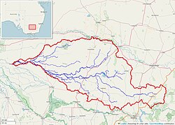
 Billabong Creek watershed (Interactive map) | |
Location of the Billabong Creek mouth in New South Wales | |
| Etymology | Aboriginal: an effluent from a river, sometimes separated from it, sometimes being joined again at time of flood.[1][2] |
| Location | |
| Country | Australia |
| State | New South Wales |
| Region | Riverina (IBRA) |
| LGA | Federation Council |
| Towns | Morven, Culcairn, Walbundrie, Rand, Jerilderie, Conargo, Wanganella, Moulamein |
| Physical characteristics | |
| Source confluence | Yarra Yarra Creek and Little Billabong Creek |
| • location | near Holbrook |
| • elevation | 322 m (1,056 ft) |
| Mouth | confluence with the Edward River |
• location | Moulamein |
• coordinates | 35°5′32″S 144°2′0″E / 35.09222°S 144.03333°E |
• elevation | 70 m (230 ft) |
| Length | 320 km (200 mi) |
| Basin size | 791 km2 (305 sq mi) |
| Basin features | |
| River system | Murray catchment, Murray-Darling basin |
| [3][4] | |
The Billabong Creek, a partly perennial stream[1] of the Murray River catchment within the Murray-Darling basin, is located in the Riverina region of New South Wales, Australia.
At 320 kilometres (200 mi) (with some estimates ranging up to 596 kilometres (370 mi)[4]), Billabong Creek is believed to be the longest creek in the world.[3]
- ^ a b c "Billabong Creek". Geographical Names Register (GNR) of NSW. Geographical Names Board of New South Wales. Retrieved 16 June 2013.
- ^ Reed, A. W. (1973). Place names of Australia. Frenchs Forest, New South Wales: Reed Books. p. 31. ISBN 0-589-50128-3.
- ^ a b "Billabong Creek Salt Interception Scheme". NSW Department of Primary Industries: Office of Water. 2009. Retrieved 16 June 2013.
- ^ a b "Map of Billabong Creek, NSW". Bonzle Digital Atlas of Australia. Retrieved 16 June 2013.
