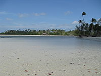
 Sumpat, Bintan Island in August 2007 | |
 Location of Bintan within Riau Islands | |
| Geography | |
|---|---|
| Coordinates | 1°04′36″N 104°30′01″E / 1.07667°N 104.50028°E |
| Highest point | Mount Bintan Besar (360 m) |
| Administration | |
| Province | Riau Islands |
| Largest settlement | Tanjungpinang (pop. 233,367) |
| Demographics | |
| Population | 387,181 (2020) |
| Pop. density | 139.39/km2 (361.02/sq mi) |
| Additional information | |
| Time zone | |
Bintan Island or Negeri Segantang Lada is an island in the Riau archipelago of Indonesia. It is part of the Riau Islands province, the capital of which, Tanjung Pinang, lies in the island's south and is the island's main community.[1][2][3][4]
Bintan's land area is 1,173 square kilometres (453 sq mi) (total area is 60,057 square kilometres (23,188 sq mi) including 96% sea area).[5] Its administrative region is designated the Bintan Regency, one of the six administrative regencies of the Riau Islands province. The city of Tanjung Pinang is an autonomous area geographically within Bintan Island but not included in the Regency.[5]
Bintan's history is traced to the early 3rd century. The island flourished as a trading post on the route between China and India, and over the centuries it came under the control of the Chinese, the British, and then the Dutch when it was declared part of the Dutch East Indies through the Anglo-Dutch Treaty of 1824.[6][7][8] In the 12th century, the Bintan island in the Strait of Malacca was known as the "Pirate Island" since the Malay pirates used to loot trading ships sailing in these waters.[9]
Singapore, the closest major city, is a 45-50 minute trip by motorised catamaran across the Singapore Strait from Bintan Resort area in the northwest of the island. The island has beaches with beach-front hotels and resorts; the most prominent of these beaches is the Bintan Resorts set over an area of 300 hectares (740 acres) of tropical environment. The archipelago of the Riau islands is right opposite to this resort across the South China Sea.[10][11] Indonesia is promoting Bintan as the next best tourist destination after Bali.[12]
- ^ Gössling, Stefan (2003). Tourism and development in tropical islands: political ecology perspectives. Edward Elgar Publishing. p. 267. ISBN 1-84376-257-9. Retrieved 2010-06-16.
- ^ "Government". Bintan net Government of Indonesia. Archived from the original on May 27, 2010. Retrieved 2010-06-14.
- ^ "Welcome to the island of Bintan". bintan.net Government of Indonesia. Archived from the original on 2012-03-08. Retrieved 2010-06-14.
- ^ Peachey, Karen; Martin Perry; Carl Grundy-Warr (1998). The Riau Islands and economic cooperation in the Singapore Indonesian border zone. IBRU. pp. 17–20. ISBN 1-897643-27-6. Retrieved 2010-06-15.
- ^ a b "Riau Island Province". Government of Indonesia. Retrieved 2010-06-17.
- ^ "Bintan Indonesia". Asinah.net. Archived from the original on 2017-08-16. Retrieved 2010-06-15.
- ^ "Time Line". Time Line. Retrieved 2010-06-14.
- ^ "History of Bintan Island". Indonesia Tourism: Government of Indonesia. Archived from the original on 2010-11-04. Retrieved 2010-06-14.
- ^ Hawk, Justice (2005). Dark Waters. iUniverse. p. 128. ISBN 0-595-36881-6. Retrieved 2010-06-15.
- ^ "Bintan Lagoon Resort". Bintan Lagoon. Archived from the original on 2012-09-17. Retrieved 2010-06-14.
- ^ "Enjoy in Bintan island". Bintan.net. Archived from the original on May 27, 2010. Retrieved 2010-06-14.
- ^ Berkmoes, Ryan Ver (2010). Lonely Planet Indonesia. Lonely Planet. pp. 455–456. ISBN 978-1-74104-830-8. Retrieved 2010-06-16.