Birch Cliff | |
|---|---|
Neighbourhood | |
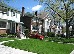
 A group of houses in the Birch Cliff neighbourhood | |
 Vicinity | |
| Coordinates: 43°41′15″N 79°16′10″W / 43.68750°N 79.26944°W | |
| Country | |
| Province | |
| City | Toronto |
| Established municipality | 1850 Scarborough Township |
| Changed municipality | 1998 Toronto from Scarborough |
| Government | |
| • MP | Bill Blair (Scarborough Southwest) |
| • MPP | Doly Begum (Scarborough Southwest) |
| • Councillor | Vacant (Ward 20 Scarborough Southwest) |
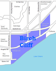
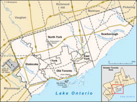
Birch Cliff is a neighbourhood in Toronto, Ontario, Canada. It is located in the eastern part of the city, part of the district of Scarborough running along the shore of Lake Ontario atop the western part of the Scarborough Bluffs. Birch Cliff has a large Irish population. About one-third of Birch Cliff residents are of Irish origin.[1][2]
The area was first developed as the home of the Toronto Hunt Club in 1895 when the region was still mostly farms and woodland. Around the club, a number of cottages were erected and one of these was named "Birch Cliff." The Victorian dwelling (believed to exist today but significantly altered) was built on Springbank Avenue for John Stark, who named it after the birch trees along the edge of the nearby Scarborough Bluffs.[3] This name was also adopted by the local post office, and became the name for the neighbourhood.
The area can also be broken down to two smaller areas west of Warden Avenue to Victoria Park Avenue:
- Blantyre located north of Kingston Road and east of Victoria Park Avenue to west of Warden Avenue
- Fallingbrook located south of Kingston Road and east of Victoria Park Avenue to west of Warden Avenue
- ^ "2011 National Household Survey Profile - Census tract". 8 May 2013.
- ^ "2011 National Household Survey Profile - Census tract". 8 May 2013.
- ^ "Beaches Living Guide". Archived from the original on 2020-09-29. Retrieved 2019-09-24.
