Biri | |
|---|---|
Village | |
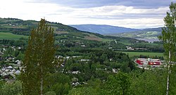
 View of the village | |
| Coordinates: 60°57′20″N 10°36′41″E / 60.95558°N 10.6115°E | |
| Country | Norway |
| Region | Eastern Norway |
| County | Innlandet |
| District | Vestoppland |
| Municipality | Gjøvik Municipality |
| Area | |
| • Total | 2.03 km2 (0.78 sq mi) |
| Elevation | 145 m (476 ft) |
| Population (2021)[1] | |
| • Total | 1,495 |
| • Density | 738/km2 (1,910/sq mi) |
| Time zone | UTC+01:00 (CET) |
| • Summer (DST) | UTC+02:00 (CEST) |
| Post Code | 2836 Biri |
Biri is a village in Gjøvik Municipality in Innlandet county, Norway. The village is located along the western shore of the lake Mjøsa, about 20 kilometres (12 mi) north of the town of Gjøvik. The Norwegian National Road 4 highway runs through the village which is near the Mjøsa Bridge about halfway between the towns of Lillehammer and Gjøvik. The 2.03-square-kilometre (500-acre) village has a population (2021) of 1,495 and a population density of 738 inhabitants per square kilometre (1,910/sq mi).[1][3]
- ^ a b c Statistisk sentralbyrå (1 January 2021). "Urban settlements. Population and area, by municipality".
- ^ "Biri, Gjøvik". yr.no. Retrieved 5 November 2022.
- ^ Thorsnæs, Geir, ed. (29 March 2022). "Biri". Store norske leksikon (in Norwegian). Kunnskapsforlaget. Retrieved 3 November 2022.

