| Black Drin | |
|---|---|
 Black Drin | |
 | |
| Location | |
| Countries | |
| Physical characteristics | |
| Source | |
| • location | Lake Ohrid |
| Mouth | |
• location | Drin |
• coordinates | 42°5′30″N 20°23′41″E / 42.09167°N 20.39472°E |
| Length | 149 km (93 mi) |
| Basin size | 3,504 km2 (1,353 sq mi) |
| Discharge | |
| • average | 118 m3/s (4,200 cu ft/s)[1] |
| Basin features | |
| Progression | Drin→ Adriatic Sea |
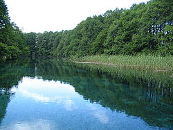
The Black Drin, or Black Drim (Albanian: Drini i Zi; Macedonian: Црн Дрим) is a river in North Macedonia and Albania. It flows out of Lake Ohrid in Struga, North Macedonia. It is 149 km (93 mi) long and its drainage basin is 3,504 km2 (1,353 sq mi). Its average discharge is 118 m3/s (4,200 cu ft/s).[2] After flowing through North Macedonia for 56 km (35 mi), the Black Drin crosses the border to Albania, west of Debar. It merges with the White Drin in Kukës to form the Drin, which flows into the Adriatic Sea. It drains most of the eastern border region of Albania.
- ^ Kabo, Mevlan (1990). Gjeografia Fizike e Shqipërisë 1 (in Albanian). Tirana, Albania: Akademia e Shkencave e RPS të Shqipërisë. p. 232.
Prurja mesatare shumëvjeçare e Drinit të Zi është 118 m3/sek, e Drinit të Bardhë 68.8 m3/sek, e Drinit (në derdhje në Bunë) 352 m3/sek që i përgjigjet një vëllimi vjetor prej 11.1 miliardë m3 ujë.
- ^ Cullaj, A.; Hasko, A.; Miho, A.; Schanz, F.; Brandl, H.; Bachofen, R. (2005). "The quality of Albanian natural waters and the human impact". Environment International. 31 (1): 138. doi:10.1016/j.envint.2004.06.008. PMID 15607787.