This article's Pollution and remediation efforts section's tone or style may not reflect the encyclopedic tone used on Wikipedia. (March 2023) |
| Blackstone River | |
|---|---|
 The Blackstone River in Massachusetts | |
 | |
| Location | |
| Country | United States |
| State | Massachusetts, Rhode Island |
| Region | New England |
| Physical characteristics | |
| Source | |
| • location | Worcester, MA |
| Mouth | |
• location | Seekonk River, at Pawtucket Falls in Pawtucket, Rhode Island |
• coordinates | 41°52′38″N 71°22′56″W / 41.8771°N 71.3822°W |
| Length | 48 mi (77 km) |
| Basin size | 540 sq mi (1,400 km2) |
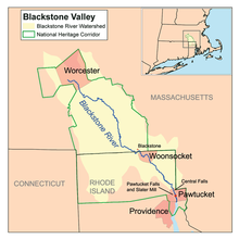
The Blackstone River in the United States is a river that flows through Massachusetts and Rhode Island. It is 48 mi (77 km) long with a drainage area of 475 mi2 (1229 km2).[1] It drains into the Pawtucket River at Pawtucket, Rhode Island. Its long history of industrial use in the watershed has caused significant pollution, with the United States Environmental Protection Agency describing it as “the most polluted river in the country because of high concentrations of toxic sediments.”[2]
- ^ "Narragansett Bay Estuary Program GIS Data Hub". narragansett-bay-estuary-program-nbep.hub.arcgis.com. Retrieved 2024-08-20.
- ^ "Blackstone River Watershed". Rhode Island Rivers Council. Archived from the original on 2012-03-16. Retrieved 2010-12-28.