| Blacktoft | |
|---|---|
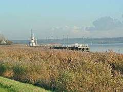
 Blacktoft Wharf, on the banks of the River Ouse | |
Location within the East Riding of Yorkshire | |
| Population | 322 (2011 Census)[1] |
| OS grid reference | SE842242 |
| • London | 150 mi (240 km) S |
| Civil parish |
|
| Unitary authority | |
| Ceremonial county | |
| Region | |
| Country | England |
| Sovereign state | United Kingdom |
| Post town | GOOLE |
| Postcode district | DN14 |
| Dialling code | 01430 |
| Police | Humberside |
| Fire | Humberside |
| Ambulance | Yorkshire |
| UK Parliament | |
Blacktoft is a village and civil parish in the East Riding of Yorkshire, England. The village is situated on the north bank of the River Ouse, 1 mile (1.6 km) west from where it joins the River Trent and becomes the Humber. It is approximately 6 miles (10 km) east from Howden and 23 miles (37 km) south-east from the county town of York. Blacktoft lies within the Parliamentary constituency of Haltemprice and Howden an area that mainly consists of middle class suburbs, towns and villages. The area is affluent, placed as the 10th most affluent in the country in a 2003 Barclays Private Clients survey,[2] and has one of the highest proportions of owner-occupiers in the country.[3]
The civil parish of Blacktoft consists of the village of Blacktoft, Bellasize, Faxfleet and Yokefleet. According to the 2011 UK Census the parish had a population of 322,[1] an increase of one on the 2001 UK census figure.[4]
Blacktoft Sands RSPB reserve lies across the Ouse. The relatively new island of Whitton Island in the Humber Estuary falls partly within the parish.[5]
- ^ a b UK Census (2011). "Local Area Report – Blacktoft Parish (1170211147)". Nomis. Office for National Statistics. Retrieved 15 February 2018.
- ^ "North tops 'real' rich league". BBC News. 14 May 2003. Retrieved 4 July 2014.
- ^ "Haltemprice and Howden". UK Polling Report. Archived from the original on 18 May 2015. Retrieved 11 May 2015.
- ^ UK Census (2001). "Local Area Report – Blacktoft Parish (1543504194)". Nomis. Office for National Statistics. Retrieved 26 November 2018.
- ^ Ordnance Survey 1:25,000 scale Explorer mapping. Retrieved 31 October 2014
