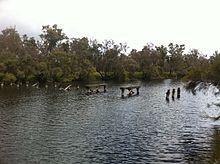
| Blackwood River | |
|---|---|
 Colour patch area at mouth of Blackwood river and start of eastern section of estuary | |
 | |
| Location | |
| Country | Australia |
| Physical characteristics | |
| Source | |
| • location | Junction of Arthur River and Balgarup River |
| • elevation | 219 metres (719 ft)[1] |
| Mouth | |
• location | Hardy Inlet, Augusta |
• elevation | sea level |
| Length | 300 kilometres (186 mi)[2] |
| Basin size | 28,100 km2 (10,849 sq mi)[3] |
| Discharge | |
| • average | 29.8 m3/s (1,050 cu ft/s)[4] |


- ^ "Bonzle Digital Atlas – Map of Blackwood River, WA". 2008. Retrieved 23 November 2008.
- ^ "History of river names – B". Western Australian Land Information Authority. Archived from the original on 19 April 2021. Retrieved 4 August 2008.
- ^ "Waters and Rivers Commission – Ribbons of Blue – Blackwood Region". 2004. Archived from the original on 4 July 2007. Retrieved 26 July 2007.
- ^ "Water Corporation – Ecological water requirementa of Blackwood Riverand tributaries" (PDF). 2007. Archived from the original (PDF) on 8 September 2007. Retrieved 26 July 2007.