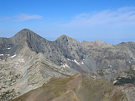
| Blanca Peak | |
|---|---|
| Sis Naajinį́ (in Navajo) | |
 View of Blanca Peak (left of center) from Mt. Lindsey | |
| Highest point | |
| Elevation | 14,351 ft (4374 m)[1] NAVD88 |
| Prominence | 5326 ft (1623 m)[1] |
| Isolation | 103.4 mi (166.4 km)[1] |
| Listing | |
| Coordinates | 37°34′38″N 105°29′09″W / 37.5772269°N 105.4858447°W[2] |
| Geography | |
| Parent range | Highest summit of the Sangre de Cristo Mountains, Sangre de Cristo Range, and Sierra Blanca Massif[1] |
| Topo map(s) | USGS 7.5' topographic map Blanca Peak, Colorado[2] |
| Climbing | |
| First ascent | August 14, 1874 by the Wheeler Survey (first recorded) |
| Easiest route | Northwest Face/North Ridge: Scramble (class 2)[3] |
| Blanca Peak Tripoint | |
|---|---|
 | |
| Highest point | |
| Elevation | 14,326 ft (4,367 m)[a][4] |
| Parent peak | Blanca Peak[4] |
| Listing | Colorado county high points |
| Coordinates | 37°34′40″N 105°29′07″W / 37.577824°N 105.48541°W[4] |
| Geography | |
| Location | Tripoint of Alamosa, Costilla, and Huerfano counties, Colorado, US High point of Huerfano County.[4] |
Blanca Peak (Navajo: Sis Naajinį́ meaning "black belted mountain";[5] Ute: Peeroradarath; Tewa: Pintsae'i'i) is the fourth highest summit of the Rocky Mountains of North America and the U.S. state of Colorado. The ultra-prominent 14,351-foot (4,374 m) peak is the highest summit of the Sierra Blanca Massif, the Sangre de Cristo Range, and the Sangre de Cristo Mountains. The fourteener is located 9.6 miles (15.5 km) north by east (bearing 9°) of the Town of Blanca, on the drainage divide separating Rio Grande National Forest and Alamosa County from the Sangre de Cristo Land Grant and Costilla County. The summit is the highest point of both counties and the entire drainage basin of the Rio Grande. Below the steep North Face of Blanca Peak two live Glaciers once developed, until extinction sometime after 1903. North & South Blanca Glaciers were located at 37° 35N.,longitude 105° 28W. Blanca Peak is higher than any point in the United States east of its longitude.[b][1][2][6]
The Blanca Peak Tripoint of Alamosa, Costilla, and Huerfano counties is located on the same drainage divide approximately 251 feet (77 m) northeast by north (bearing 30°) of the Blanca Peak summit at the boundary of the San Isabel National Forest. The Blanca Peak Tripoint is the highest point in Huerfano County.[4]
- ^ a b c d e f "Blanca Peak, Colorado". Peakbagger.com. Retrieved January 2, 2016.
- ^ a b c "Blanca Peak". Geographic Names Information System. United States Geological Survey, United States Department of the Interior. Retrieved October 19, 2014.
- ^ "Blanca Peak Routes". 14ers.com.
- ^ a b c d e "Blanca Peak-Northeast Slope, Colorado". Peakbagger.com. Retrieved November 14, 2014.
- ^ Carey, Harey. "Mount Blanca (Sisnaajini) Navajo Sacred Mountain". Navajo People.
- ^ Beeton, Jared Maxwell; Saenz, Charles Nicholas; Waddell, Benjamin James (2020-08-24). The Geology, Ecology, and Human History of the San Luis Valley. University Press of Colorado. ISBN 978-1-64642-040-7.
Cite error: There are <ref group=lower-alpha> tags or {{efn}} templates on this page, but the references will not show without a {{reflist|group=lower-alpha}} template or {{notelist}} template (see the help page).
