| Blidinje plateau | |
|---|---|
 | |
| Highest point | |
| Elevation | 1,150–2,228 m (3,773–7,310 ft) |
| Coordinates | 43°37′N 17°37′E / 43.62°N 17.61°E |
| Dimensions | |
| Length | 22 km (14 mi) South-North |
| Width | 17 km (11 mi) East-West |
| Area | 513.45 km2 (198.24 sq mi) |
| Naming | |
| Nickname | Bosnianherzegovinian Tibet |
| Geography | |
| State | Bosnia and Herzegovina |
| Region | Herzegovina |
| Canton |
|
| Municipality |
|
| Town |
|
| Parent range | Dinaric Alps |
| Geology | |
| Formed by | Thrust faulting |
| Orogeny | Alpine orogeny[1] |
| Rock age | Late Mesozoic-Cenozoic (Paleogene) |
| Mountain type | sedimentation of limestone deposit |
| Rock type | carbonate limestone |
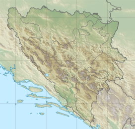
Blidinje plateau (Croatian: Blidinjska visoravan) is a karst plateau in Bosnia and Herzegovina, situated at the heart of Dinaric Alps, between major mountains of the range, Čvrsnica, Čabulja and Vran, with characteristic karstic features such as Dugo Polje field, Blidinje Lake, Grabovica and Drežnica valleys, and others.[2] It represents important natural, hydrogeological reservation in karst of Bosnia and Herzegovina, with significant cultural and historical heritage, and Dinarides in general.[3]
- ^ "Hercegovačka kamena šuma od koje zastaje dah". Blidinje.NET (in Croatian). 15 November 2020. Retrieved 7 April 2023.
- ^ Environmental Performance Reviews: Bosnia and Herzegovina. United Nations Economic Commission for Europe Committee on Environmental. 2004. ISBN 978-92-1-116915-7. Retrieved 18 April 2022.
- ^ "Nature Park Blidinje". Archived from the original on 18 February 2018. Retrieved 16 October 2015.

