This article needs additional citations for verification. (September 2012) |
Bliedersdorf
Bliedersdorf (German) Bliersdörp (Low Saxon) | |
|---|---|
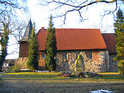
 St. Catherine's Church | |
Location of Bliedersdorf within Stade district  | |
| Coordinates: 53°28′58″N 9°34′16″E / 53.48278°N 9.57111°E | |
| Country | Germany |
| State | Lower Saxony |
| District | Stade |
| Municipal assoc. | Horneburg |
| Subdivisions | 3 villages |
| Government | |
| • Mayor | Tobias Terne[1] (CDU) |
| Area | |
| • Total | 12.41 km2 (4.79 sq mi) |
| Elevation | 23 m (75 ft) |
| Population (2022-12-31)[2] | |
| • Total | 1,831 |
| • Density | 150/km2 (380/sq mi) |
| Time zone | UTC+01:00 (CET) |
| • Summer (DST) | UTC+02:00 (CEST) |
| Postal codes | 21640 |
| Dialling codes | 04163 |
| Vehicle registration | STD |
| Website | www.horneburg.de |
Bliedersdorf (in High German, in Low Saxon: Bliersdörp) is a municipality in the district of Stade, Lower Saxony, Germany. It is east of Nottensdorf, southwest of Horneburg, and northwest of the simple dolmen megaliths of Grundoldendorf.
Like the rest of Stade, it is part of the Elbe-Weser Triangle.


