Bobo-Dioulasso
Bɔbɔjulaso (Dyula) | |
|---|---|
 Bobo-Dioulasso marketplace, 2006 | |
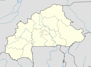
Location within Burkina Faso, West Africa | |
| Coordinates: 11°11′N 4°17′W / 11.183°N 4.283°W | |
| Country | |
| Region | Hauts-Bassins Region |
| Province | Houet Province |
| Founded | 15th century |
| Area | |
| • Total | 136.78 km2 (52.81 sq mi) |
| Elevation | 445 m (1,460 ft) |
| Population (2023 census)[1] | |
| • Total | 1,129,000 |
| • Density | 8,300/km2 (21,000/sq mi) |
| Time zone | UTC+0 (GMT) |
| Area code | +226 20 |
| Climate | Aw |
| Website | bobodioulasso.net |
11°11′N 4°17′W / 11.183°N 4.283°W Bobo-Dioulasso (Dyula: Bɔbɔjulaso N'Ko script: ߓߐ߬ߓߐߖߎ߬ߟߊ߬ߛߏ߫, Mossi: Sɩa) is a city in Burkina Faso with a population of 1,129,000 (as of 2023[update]);[1] it is the second-largest city in the country, after Ouagadougou, Burkina Faso's capital. The name means "home of the Bobo-Dioula".
The local Bobo-speaking population (related to the Mande) refers to the city simply as Sia. There are two distinct dialects spoken of Jula, based on the origins of different peoples who speak this language. The city is situated in the southwest of the country, in the Houet Province, some 350 km (220 mi) from Ouagadougou. Bobo-Dioulasso is significant both economically (agricultural trade, textile industry) and culturally, as it is a major center of culture and music.
- ^ a b Citypopulation.de Population of the major cities in Burkina Faso
