| Bogue Falaya | |
|---|---|
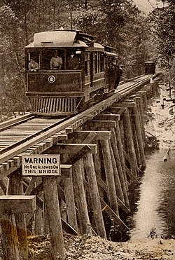
 Wooden bridge crossing the Bogue Falaya River near Covington, Louisiana, 1910s. | |
 Bogue Falaya | |
| Location | |
| Country | United States |
| State | Louisiana |
| Parishes | |
| Physical characteristics | |
| Source | |
| • location | Washington Parish, Louisiana |
| • coordinates | 30°42′11″N 90°09′55″W / 30.70306°N 90.16528°W |
| Mouth | Tchefuncte River |
• location | Covington, St. Tammany Parish, Louisiana |
• coordinates | 30°26′23″N 90°06′59″W / 30.43972°N 90.11639°W |
| Length | 28 mi (45 km) |
| Basin features | |
| Cities | Covington |
| Tributaries | |
| • left | Abita River |
The Bogue Falaya, also known as the Bogue Falaya River, is a 28-mile-long (45 km)[1] river in southeastern Louisiana in the United States.[2] It is a tributary of the Tchefuncte River, which flows to Lake Pontchartrain. The river flows through an area of mixed pine-hardwood and bottomland hardwood forests on the Gulf Coastal Plain.[3]
The Bogue Falaya rises in southwestern Washington Parish and flows generally south-southeastwardly through western St. Tammany Parish, past Covington, where it collects the Abita River.[4] It joins the Tchefuncte River about 10 miles (16 km) upstream of that river's mouth at Lake Pontchartrain.[2]
The name is derived from the Choctaw words bogu, “river,” and falaya, "long."[5][6]
A portion of the Bogue Falaya in St. Tammany Parish has been designated a "Natural and Scenic River" by the state government of Louisiana.[3]
- ^ U.S. Geological Survey. National Hydrography Dataset high-resolution flowline data. The National Map Archived 2012-03-29 at the Wayback Machine, accessed June 20, 2011
- ^ a b Columbia Gazetteer of North America entry Archived August 25, 2005, at the Wayback Machine
- ^ a b Louisiana Department of Environmental Quality (2002). State of Louisiana Water Quality Management Plan Archived 2006-10-09 at the Wayback Machine: Appendix B: Descriptions of Louisiana's Natural and Scenic Rivers (PDF)
- ^ DeLorme (2003). Louisiana Atlas & Gazetteer. Yarmouth, Maine: DeLorme. ISBN 0-89933-286-2
- ^ Bushnell, D.I. (1909). The Choctaw of Bayou Lacomb, St. Tammany Parish, Louisiana. Washington: Government Printing Office. p. 7. No copyright in the United States.
- ^ Leeper, Clare D'Artois (19 October 2012). Louisiana Place Names: Popular, Unusual, and Forgotten Stories of Towns, Cities, Plantations, Bayous, and Even Some Cemeteries. LSU Press. p. 42. ISBN 978-0-8071-4740-5.