| Bohot | |
|---|---|
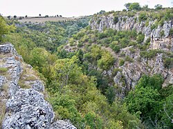
 The river gorge at Hotnitsa | |
 | |
| Location | |
| Country | Bulgaria |
| Physical characteristics | |
| Source | |
| • location | S of Novo Selo, Fore-Balkan |
| • coordinates | 43°3′51.84″N 25°22′15.96″E / 43.0644000°N 25.3711000°E |
| • elevation | 469 m (1,539 ft) |
| Mouth | |
• location | Rositsa |
• coordinates | 43°12′50.04″N 25°36′7.92″E / 43.2139000°N 25.6022000°E |
• elevation | 57 m (187 ft) |
| Length | 32 km (20 mi) |
| Basin size | 99 km2 (38 sq mi) |
| Basin features | |
| Progression | Rositsa→ Yantra→ Danube→ Black Sea |
The Bohot (Bulgarian: Бохот) is a 32 km-long river in northern Bulgaria, a right tributary of the Rositsa, itself a left tributary of the river Yantra of the Danube basin.[1]
The Bohot takes its source under the name Kurudere at an altitude of 469 m just south of the village of Novo Selo in the Fore-Balkan. It flows through the village of Balvan and the small Bahanitsa Reservoir and heads northeast, cutting through the western part of the Tarnovo Heights. Some 2 km west of Hotnitsa it forms the 30 m high Hotnitsa Waterfall. Downstream of the village the Bohot enters the Danubian Plain and flows into the Rositsa at an altitude of 67 m, about 800 m southwest of the remains of the Roman city of Nicopolis ad Istrum.[1]
Its drainage basin covers a territory of 99 km2 or 4.4% of the Rositsa's total. It is primarily fed by karst spring waters.[1]
The river flows entirely in Veliko Tarnovo Province. There are two villages along its course, Balvan and Hotnitsa in Veliko Tarnovo Municipality. Its waters are utilized for irrigation.[1]
- ^ a b c d Geographic Dictionary of Bulgaria 1980, p. 61