Bolivar, Ohio | |
|---|---|
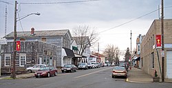
 Canal Street in Bolivar in 2006 | |
 Location of Bolivar, Ohio | |
 Location of Bolivar in Tuscarawas County | |
| Coordinates: 40°39′15″N 81°27′18″W / 40.65417°N 81.45500°W | |
| Country | United States |
| State | Ohio |
| County | Tuscarawas |
| Township | Lawrence |
| Area | |
| • Total | 0.96 sq mi (2.48 km2) |
| • Land | 0.95 sq mi (2.46 km2) |
| • Water | 0.01 sq mi (0.02 km2) |
| Elevation | 932 ft (284 m) |
| Population (2020) | |
| • Total | 1,000 |
| • Estimate (2023)[3] | 965 |
| • Density | 1,053.74/sq mi (406.66/km2) |
| Time zone | UTC-5 (Eastern (EST)) |
| • Summer (DST) | UTC-4 (EDT) |
| ZIP code | 44612 |
| Area code | 330 |
| FIPS code | 39-07594[4] |
| GNIS feature ID | 2398148[2] |
Bolivar (/ˈbɒlɪvər/, rhymes with Oliver)[5] is a village in Tuscarawas County, Ohio, United States. The population was 1,000 at the 2020 census. Bolivar is also home to Fort Laurens, the only American Revolutionary War-era fort in what is now Ohio.[6][7]
- ^ "ArcGIS REST Services Directory". United States Census Bureau. Retrieved September 20, 2022.
- ^ a b U.S. Geological Survey Geographic Names Information System: Bolivar, Ohio
- ^ "Annual Estimates of the Resident Population for Incorporated Places in Ohio: April 1, 2020 to July 1, 2023". United States Census Bureau. Retrieved June 4, 2024.
- ^ "U.S. Census website". United States Census Bureau. Retrieved January 31, 2008.
- ^ "A Pronunciation Guide to places in Ohio -- E.W.Scripps School of". Archived from the original on July 25, 2017. Retrieved December 17, 2008.
- ^ "About Fort Laurens". Friends of Fort Laurens Foundation. Archived from the original on October 19, 2009. Retrieved August 25, 2009.
- ^ "Friends of Fort Laurens Foundation". Friends of Fort Laurens Foundation. Retrieved August 25, 2009.