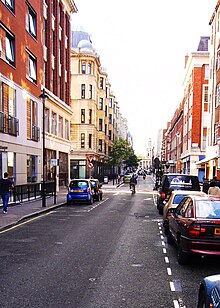
 Bolsover Street looking north towards Holy Trinity Church and Regent's Park | |
| Former name(s) | Norton Street |
|---|---|
| Length | 0.2 mi (0.32 km) |
| Postal code | W1 |
| Coordinates | 51°31′19.3″N 0°8′34.6″W / 51.522028°N 0.142944°W |
| south end | New Cavendish Street |
| north end | Great Portland Street |
Bolsover Street is in the Parish of St Marylebone in London's West End. In administrative terms it lies within the City of Westminster's West End Ward and is partly in the Harley Street Conservation Area whilst also sitting on the edges of the Regents Park and East Marylebone Conservation Areas.[1][2][3]
The predominant land use on Bolsover Street is office business use, mixed with hotels (and YHA Hostel), medical and professional activity. Numerous communications, new media and broadcast entities are located in offices on the street. Residential presence on the street is strongest at its northern and closest end to Regent's Park and Regent's Place. The Royal National Orthopaedic Hospital has been present on the street since 1907.
- ^ "Westminster City Council: Map of Conservation Areas, accessed 2010-05-21". Archived from the original on 11 September 2010. Retrieved 30 August 2010.
- ^ "Westminster City Council: Harley Street Conservation Area Audit 2008, accessed 2010-05-21" (PDF). Archived (PDF) from the original on 28 July 2011. Retrieved 15 July 2010.
- ^ http://myfitzrovia.wordpress.com/ Archived 27 May 2016 at the Wayback Machine East Marylebone Influences, accessed May 2011