| Bondi Junction Sydney, New South Wales | |||||||||||||||
|---|---|---|---|---|---|---|---|---|---|---|---|---|---|---|---|
 | |||||||||||||||
 | |||||||||||||||
| Population | 10,361 (SAL 2021)[1] | ||||||||||||||
| Established | 1854 | ||||||||||||||
| Postcode(s) | 2022 | ||||||||||||||
| Elevation | 85 m (279 ft) | ||||||||||||||
| Area | 1.07 km2 (0.4 sq mi)[2] | ||||||||||||||
| Location | 6 km (4 mi) east of Sydney CBD | ||||||||||||||
| LGA(s) | Waverley Council | ||||||||||||||
| State electorate(s) | |||||||||||||||
| Federal division(s) | Wentworth | ||||||||||||||
| |||||||||||||||

Bondi Junction is an eastern suburb of Sydney, in the state of New South Wales, Australia. It is 6 kilometres east of the Sydney central business district and is part of the local government area of Waverley.[3]
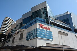
Bondi Junction is a largely commercial area which has undergone many changes since the late 20th century. There have been many major commercial and residential developments around the main street and surrounding area, notably a new bus/rail interchange and large shopping mall. Many of the original pubs have been maintained, notably, the Nelson Hotel, so named because of its location on Nelson Street. Bondi Beach is a neighbouring suburb to the east with its namesake beach. Similarly named Bondi and North Bondi are also neighbouring suburbs.
Bondi Junction and the neighbouring area is well known for its famous rugby league team, the Sydney Roosters, still officially known as the Eastern Suburbs District Rugby League Football Club.
- ^ Australian Bureau of Statistics (28 June 2022). "Bondi Junction (suburb and locality)". Australian Census 2021 QuickStats. Retrieved 28 June 2022.
- ^ Bondi Junction Archived 15 April 2024 at the Wayback Machine accessed from the original on 15 April 2024.
- ^ Gregory's Sydney Street Directory, Gregory's Publishing Company, 2007