This article needs additional citations for verification. (August 2022) |
| Borroloola Northern Territory | |||||||||
|---|---|---|---|---|---|---|---|---|---|
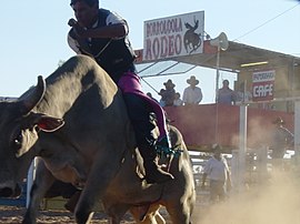
 The Borroloola rodeo is held in August each year | |||||||||
| Coordinates | 16°04′13″S 136°18′26″E / 16.07028°S 136.30722°E | ||||||||
| Population | 871 (2016 census)[1] | ||||||||
| Postcode(s) | 0854 | ||||||||
| Elevation | 17 m (56 ft) | ||||||||
| Location |
| ||||||||
| LGA(s) | Roper Gulf Region | ||||||||
| Territory electorate(s) | Barkly | ||||||||
| Federal division(s) | Lingiari | ||||||||
| |||||||||
Borroloola (Garrwa: Burrulula) is a town in the Northern Territory of Australia. It is located on the McArthur River, about 50 km (31 mi) upstream from the Gulf of Carpentaria.
