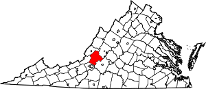
Botetourt County | |
|---|---|
 Botetourt County Courthouse | |
 Location within the U.S. state of Virginia | |
 Virginia's location within the U.S. | |
| Coordinates: 37°33′N 79°48′W / 37.55°N 79.8°W | |
| Country | |
| State | |
| Founded | 1770 |
| Named for | Lord Botetourt |
| Seat | Fincastle |
| Largest community | Cloverdale |
| Area | |
| • Total | 546 sq mi (1,410 km2) |
| • Land | 541 sq mi (1,400 km2) |
| • Water | 4.7 sq mi (12 km2) 0.9% |
| Population (2020) | |
| • Total | 33,596 |
| • Density | 62/sq mi (24/km2) |
| Time zone | UTC−5 (Eastern) |
| • Summer (DST) | UTC−4 (EDT) |
| Congressional district | 6th |
| Website | botetourtva |
Botetourt County (/ˈbɒtətɒt/ BOT-ə-tot) is a US county that lies in the Roanoke Region of Virginia. Located in the mountainous portion of the state, the county is bordered by two major ranges, the Blue Ridge Mountains and the Appalachian Mountains.
Botetourt County was created in 1770 from part of Augusta County and was named for Norborne Berkeley, 4th Baron Botetourt. It originally comprised a vast area, which included the southern portion of present-day West Virginia and all of Kentucky. Portions were set off to form new counties beginning in 1772, until the current borders were established in 1851.
Botetourt County is part of the Roanoke Virginia Metropolitan Statistical Area, and the county seat is the town of Fincastle.[1] As of the 2020 census, the county population was 33,596.[2]
- ^ Roanoke Region of Virginia
- ^ "Botetourt County, Virginia". United States Census Bureau. Retrieved January 30, 2022.


