| Boundary Cone | |
|---|---|
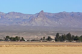
 View of Boundary Cone from Mohave Valley, on the Colorado River | |
| Highest point | |
| Elevation | 3,432 ft (1,046 m) NAVD 88[1] |
| Prominence | 750 ft (229 m)[1] |
| Coordinates | 34°59′02″N 114°24′56″W / 34.983788761°N 114.415665406°W[2] |
| Geography | |
| Location | Mohave County, Arizona, U.S |
| Parent range | Black Mountains |
| Topo map | USGS Boundary Cone |
| Geology | |
| Mountain type | volcanic neck[3] |
| Climbing | |
| Easiest route | from Oatman, Arizona |
Boundary Cone is a geologic promontory located in the western foothills of the Black Mountains in Mohave County, Arizona.[4] The peak is to the east of the Mohave Valley, northeast of Needles, California, and southeast of Bullhead City. The peak is about 4 miles (6 km) southwest of the mountain community of Oatman and 12 miles (19 km) east of the Colorado River.
- ^ a b "Boundary Cone, Arizona". Peakbagger.com. Retrieved 2012-04-22.
- ^ "Boundary Cone". NGS Data Sheet. National Geodetic Survey, National Oceanic and Atmospheric Administration, United States Department of Commerce. Retrieved 2016-08-15.
- ^ Chronic, Halka (1983). Roadside Geology of Arizona. p. 85. ISBN 9780878421473.
- ^ "Boundary Cone". Geographic Names Information System. United States Geological Survey, United States Department of the Interior. Retrieved 2016-08-15.

