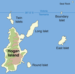
 Map of Hogan Group showing Boundary Islet | |
Location of the Boundary Islet in Bass Strait | |
| Geography | |
|---|---|
| Location | Bass Strait |
| Coordinates | 39°11′54″S 147°01′18″E / 39.198355°S 147.021643°E |
| Archipelago | Hogan Group |
| Area | 2 ha (4.9 acres) |
| Length | 141 m (463 ft) |
| Administration | |
Australia | |
| States | |
Boundary Islet, historically known as North East Islet, is a 2-hectare (4.9-acre) islet in the Hogan Island Group of Bass Strait, at a latitude of 39°12′ S, about 56 kilometres (35 mi) east of the southernmost point of mainland Victoria. The islet straddles the maritime border of the Australian states of Victoria and Tasmania, hence the name.[1]
- ^ "State and Territory Borders: Shortest Border". Geoscience Australia. Commonwealth of Australia. 11 September 2007. Archived from the original on 22 August 2008. Retrieved 18 September 2022.
A little known fact is that there is a land border between Tasmania and Victoria. Straddling the declared parallel line of latitude of 39° 12' S separating the two states is Boundary Islet.
