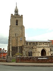
| Boxford | |
|---|---|
 St. Mary's Church, Boxford | |
Location within Suffolk | |
| Area | 0.5143 km2 (0.1986 sq mi) |
| Population | 833 (2021) |
| • Density | 1,620/km2 (4,200/sq mi) |
| District | |
| Shire county | |
| Region | |
| Country | England |
| Sovereign state | United Kingdom |
| Post town | Sudbury |
| Postcode district | CO10 |
| Dialling code | 01787 |
| Police | Suffolk |
| Fire | Suffolk |
| Ambulance | East of England |
| UK Parliament | |
| Website | www |
 | |

Boxford is a village and civil parish in the Babergh district of Suffolk, England. Located around six miles east of Sudbury straddling the River Box and skirted by the Holbrook. The parish includes the hamlets of Calais Street, Hagmore Green and Stone Street. In 2021 the built-up area had a population of 833.[1] In 2021 the parish had a population of 1403.[2] The parish borders Assington, Edwardstone, Groton, Kersey, Newton and Polstead.[3] There are 87 listed buildings in Boxford.[4] Boxford became a conservation area in 1973.[5]
- ^ "Boxford". City Population. Retrieved 17 January 2024.
- ^ "Boxford". City Population. Retrieved 17 January 2024.
- ^ "Areas touching Boxford". Mapit. Retrieved 17 January 2024.
- ^ "Listed buildings in Boxford, Babergh, Suffolk". British Listed Buildings. Retrieved 17 January 2024.
- ^ "Boxford Conservation Area appraisal". Babergh District Council. Retrieved 17 January 2024.
