Brandonville, West Virginia | |
|---|---|
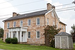
 Hagans Homestead (1830) | |
 Location of Brandonville in Preston County, West Virginia. | |
| Coordinates: 39°39′59″N 79°37′17″W / 39.66639°N 79.62139°W | |
| Country | United States |
| State | West Virginia |
| County | Preston |
| Area | |
| • Total | 0.39 sq mi (1.00 km2) |
| • Land | 0.39 sq mi (1.00 km2) |
| • Water | 0.00 sq mi (0.00 km2) |
| Elevation | 1,805 ft (550 m) |
| Population | |
| • Total | 136 |
| • Estimate (2021)[3] | 136 |
| • Density | 272.73/sq mi (105.19/km2) |
| Time zone | UTC-5 (Eastern (EST)) |
| • Summer (DST) | UTC-4 (EDT) |
| ZIP code | 26525 |
| Area code | 304 |
| FIPS code | 54-09844[4] |
| GNIS feature ID | 1553965[2] |
| Website | https://local.wv.gov/brandonville/Pages/default.aspx |
Brandonville is a town in northern Preston County, West Virginia, United States. The population was 136 at the 2020 census.[3] It is part of the Morgantown metropolitan area.
- ^ "2019 U.S. Gazetteer Files". United States Census Bureau. Retrieved August 7, 2020.
- ^ a b U.S. Geological Survey Geographic Names Information System: Brandonville, West Virginia
- ^ a b c Bureau, US Census. "City and Town Population Totals: 2020-2021". Census.gov. US Census Bureau. Retrieved July 3, 2022.
{{cite web}}:|last1=has generic name (help) - ^ "U.S. Census website". United States Census Bureau. Retrieved January 31, 2008.