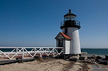
 Brant Point Light in 2009 | |
 | |
| Location | Nantucket, US |
|---|---|
| Coordinates | 41°17′N 70°05′W / 41.29°N 70.09°W |
| Tower | |
| Constructed | 1901 |
| Foundation | stone piling |
| Construction | lumber |
| Automated | 1965 |
| Height | 26 ft (7.9 m) |
| Shape | conical, footbridge to shore |
| Markings | white (tower), black (lantern) |
| Heritage | National Register of Historic Places listed place |
| Fog signal | bell (original), horn: 1 every 10s (current) |
| Light | |
| Focal height | 26 ft (7.9 m) |
| Lens | fifth order Fresnel lens |
| Range | 10 nmi (19 km; 12 mi) |
| Characteristic | Oc R 4s |
| 1856 lighthouse | |
 The 1856 tower is still standing. (U.S.Coast Guard photo) | |
| Constructed | 1856 |
| Construction | concrete (foundation), granite (foundation), brick (tower) |
| Shape | cylinder |
| Deactivated | 1900 |
| Lens | fourth order Fresnel lens |
Brant Point Light Station | |
| Area | 3.2 acres (1.3 ha) |
| MPS | Lighthouses of Massachusetts TR |
| NRHP reference No. | 87002029[1][2][3] |
| Added to NRHP | September 28, 1987 |
Brant Point Light is a lighthouse located on Nantucket Island. The station was established in 1746, automated in 1965, and is still in operation. The current tower was added to the National Register of Historic Places on October 28, 1987; it has the distinction of being the tenth light on the point, in addition to several range lights. Four of the others burned or blew down, two were condemned, two were unsatisfactory, and the remaining one stands unused.
- ^ Cite error: The named reference
cgllwas invoked but never defined (see the help page). - ^ The coordinates shown are the official coordinates from the cited Light List and are shown to the precision given there.
- ^ "National Register Information System". National Register of Historic Places. National Park Service. March 13, 2009.