Britstown | |
|---|---|
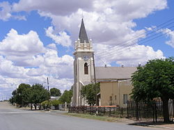
 Church in Britstown | |
| Coordinates: 30°35′S 23°30′E / 30.583°S 23.500°E | |
| Country | South Africa |
| Province | Northern Cape |
| District | Pixley ka Seme |
| Municipality | Emthanjeni |
| Area | |
| • Total | 62.6 km2 (24.2 sq mi) |
| Population (2011)[1] | |
| • Total | 5,145 |
| • Density | 82/km2 (210/sq mi) |
| Racial makeup (2011) | |
| • Black African | 26.7% |
| • Coloured | 68.4% |
| • Indian/Asian | 0.4% |
| • White | 4.0% |
| • Other | 0.5% |
| First languages (2011) | |
| • Afrikaans | 80.9% |
| • Xhosa | 13.8% |
| • Sotho | 1.4% |
| • English | 1.4% |
| • Other | 2.5% |
| Time zone | UTC+2 (SAST) |
| Postal code (street) | 8782 |
| PO box | 8782 |
| Area code | 053 |
Britstown is a small farming town situated in the Northern Cape province of South Africa, in the Pixley ka Seme District Municipality, Emthanjeni Local Municipality. The town is named after Hans Brits who settled here after he accompanied David Livingstone on a venture into the interior.
Britstown lies in the heart of the Central Karoo and is located exactly halfway between Cape Town (via Three Sisters) and Johannesburg (via Kimberley) on the N12 national route, and thus is about 700 km from both cities. The N10 national route crosses the N12 500m outside the town. De Aar is the closest big town and lies 50 km East from Britstown on the N10.

